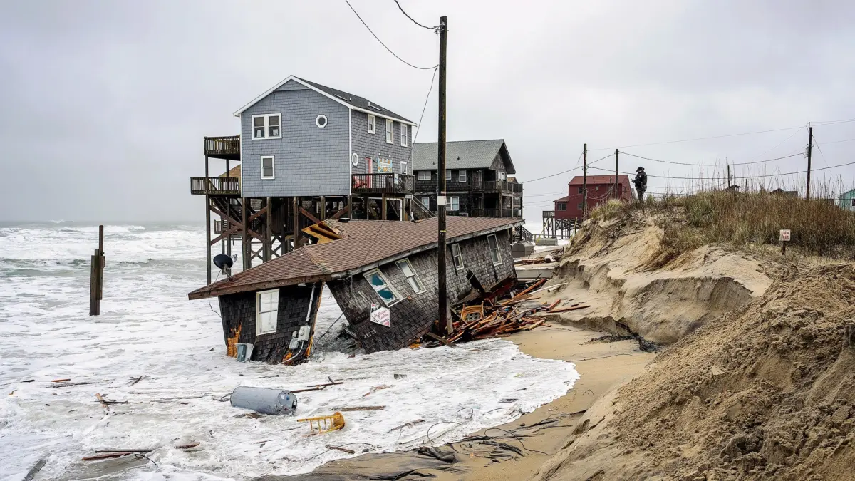
An early-season nor’easter is currently battering a vulnerable stretch of North Carolina’s Outer Banks, unleashing powerful surf that is threatening dozens of coastal homes and prompting urgent warnings from local officials that an entire row of properties could soon be swallowed by the advancing ocean.
The severe weather system has triggered immediate emergency responses across the region. On Thursday, the National Park Service announced that Cape Hatteras National Seashore was closing the beach from the northern edge of Rodanthe to the town’s pier. According to park officials, the closure was implemented because multiple threatened oceanfront structures now pose immediate risks to public safety as the storm surges against the coast.
For local residents, the unfolding crisis is an all-too-familiar and devastating scene. Since May 2020, a staggering 32 homes have collapsed into the Atlantic Ocean as relentless erosion steadily redraws the shoreline of the barrier islands. These structural losses have been heavily concentrated around Rodanthe and Buxton, two small, tightly knit villages situated on Hatteras Island, one of the narrow ribbons of sand that make up the iconic Outer Banks chain.
The scope of the ongoing crisis was underscored during a state coastal management meeting last November. At the gathering, local and state officials revealed they were actively tracking roughly 100 threatened structures across Rodanthe and Buxton alone, issuing grim warnings that additional collapses were virtually inevitable.
“If every one of those structures falls in,” Cape Hatteras National Seashore Superintendent Dave Hallac warned at the time, “there would be another 100 right behind them.”
Years of Erosion Have Put More Homes at the Water’s Edge
In the months following Hallac’s public warning, at least five additional homes have already succumbed to the surf and collapsed into the sea, according to National Park Service records. Now, the latest nor’easter is subjecting the remaining threatened properties to yet another punishing round of high-velocity waves and relentless tidal surges.
The storm’s immediate impacts have already disrupted vital regional infrastructure. On Thursday, extreme tides broke through protective sand dunes on Pea Island, located just north of Rodanthe. The breach damaged roughly 500 feet of pavement, forcing the immediate closure of N.C. 12, the primary thoroughfare connecting the northern Outer Banks. Meanwhile, the National Weather Service issued severe warnings, predicting that breaking waves would peak at 10 to 15 feet through Saturday evening.
This aggressive pounding surf is hammering a coastline that looks radically different from the landscape that existed when many of the area’s beachfront homes were originally constructed.
Michael McDaniel experienced this dramatic transformation firsthand. In 2011, McDaniel purchased his Buxton beach house for approximately $500,000. At the time of the purchase, roughly 250 feet—nearly the length of an entire football field—of protective dune separated his front porch from the open waters of the Atlantic. However, in the 15 years since he bought the property, aggressive erosion has entirely erased that crucial buffer zone, leaving his home completely uninhabitable and standing precariously at the water’s edge.
This rapid environmental retreat is not an isolated incident affecting only McDaniel’s property. The Outer Banks are classic barrier islands, characterized by narrow strips of sand that naturally shift and migrate as waves, winds, and ocean currents transport sand up and down the coast. Coastal erosion is an inherent part of this natural geological process.
However, the rate of erosion has accelerated to alarming levels in certain areas. According to data from Dare County, the shoreline in parts of Rodanthe has retreated at an average rate of about 13 feet per year. In sections of Buxton, chronic historical erosion has routinely exceeded 20 feet annually.
While these long-term averages provide a baseline for the changing landscape, they often mask much more abrupt and catastrophic losses that occur during severe weather events. During Hurricane Erin in August 2025, for instance, 75 residential structures sustained varying degrees of damage across the two villages. In the two months that immediately followed the hurricane, a succession of offshore storms triggered the collapse of 16 homes.
Compounding the crisis is the history of local development. As the shoreline inexorably moves inland, it is increasingly colliding with residential developments constructed decades ago. County real estate records show that the vast majority of homes currently facing imminent danger were built in the 1980s and 1990s, an era when the ocean was situated much farther away from the building lots.
Homeowners Are Running Out of Options
For property owners caught in the path of this slow-moving disaster, the available options are severely limited, leaving many trapped in difficult financial and practical predicaments.
While standard flood insurance policies typically cover direct physical damage caused by rising waters, they generally do not pay out simply because chronic erosion has placed a structure in imminent physical danger.
“The NFIP policy pays for a direct physical loss from flood,” explains Lisa Sharrard, a North Carolina flood insurance agent and Certified Floodplain Manager. “So there has to be a flooding event, not normal high tide.”
Sharrard adds that standard policies explicitly exclude coverage for damages caused by gradual, long-term environmental processes. “The SFIP does not cover damage caused by gradual erosion.”
This regulatory and financial reality leaves homeowners like McDaniel trapped between a rock and a hard place: stuck owning a home they can no longer safely utilize, yet unable to collect insurance payouts because the property has not yet suffered the specific type of catastrophic damage that policies are engineered to cover.
“If they have a policy, the policy may pay if the house collapses due to erosion,” Sharrard notes. “In the meantime, they have a house they cannot use and debris to clean up after. Most are trying to move if they can.”
Even in scenarios where federal flood coverage ultimately applies, financial relief is strictly capped. A standard National Insurance Flood Program policy provides no more than $250,000 in building coverage for a single-family home—an amount that falls woefully short of the actual financial needs of impacted homeowners facing total property loss.
Some residents have attempted drastic and expensive engineering feats to save their investments. A Rodanthe couple previously shared that they spent more than $200,000 to physically lift their house and move it roughly 100 feet inland after erosion brought the ocean dangerously close to their doorstep. However, those homeowners possessed a luxury that many others lack: enough remaining land behind their existing footprint to relocate the structure elsewhere on the same lot.
Protecting the Shoreline Costs Millions—and Doesn’t Last Forever
As the crisis widens, communities are left grappling with fundamental questions about how to protect remaining properties and infrastructure from the encroaching sea.
One primary strategy is attempting to halt the retreat of the shoreline altogether. However, North Carolina largely prohibits the construction of permanent seawalls and hard stabilization structures along its ocean beaches, forcing local municipalities to rely heavily on beach nourishment. This engineering practice involves dredging sand from offshore sources and pumping it onto eroding beaches to artificially rebuild a protective buffer of sand in front of homes and public roadways.
The financial burden of this approach is immense. In 2022, Buxton spent approximately $18.1 million to replenish 2.9 miles of local shoreline. Just two years later, a severe coastal storm swept away an estimated 175,000 cubic yards of that newly placed sand. Local engineers estimated that replacing that lost volume alone would cost an additional $10.2 million.
To combat the ongoing loss, dredging vessels returned to the area this summer. By September 16, maritime crews had successfully placed about 1.5 million cubic yards of fresh sand along the Buxton coast—finishing the work just over a week before the current nor’easter began battering Hatteras Island.
Even under normal weather conditions, Dare County officials note that beach nourishment projects have a limited lifespan, typically lasting about five years before the sand erodes away and the process must be repeated.
In Rodanthe, local leaders argue that even this expensive fix is financially untenable. During the November state meeting, Dare County Manager Bobby Outten bluntly addressed the limitations of the strategy.
“In Rodanthe there isn’t enough money to solve the problem with beach nourishment,” Outten told state coastal officials.
Meanwhile, long-term environmental projections indicate that the pressures facing the barrier islands will only intensify. The Fifth National Climate Assessment projects an additional 15 to 22 inches of sea-level rise around the Outer Banks by the year 2050, a trend that will allow future high tides and coastal storms to push farther inland than ever before.